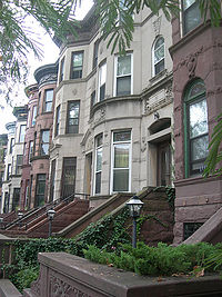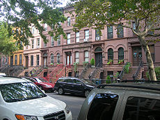
Stuyvesant Heights is a neighborhood in north-central Brooklyn, a part of (New York City) settled in the mid-17th century before the borough of Brooklyn was incorporated as a city. The area, presently gentrifying, can boast of some of Brooklyn’s most handsome and historic brownstones and grand old apartment buildings.
Stuyvesant Heights is one of the four neighborhoods comprising the widely-known enclave of Bedford-Stuyvesant. The other neighborhoods are Bedford, Ocean Hill, and Weeksville.
Neighborhood boundaries
The boundaries of the Stuyvesant Heights neighborhood can be described by the following circuit:
- Beginning at the northwesternmost point in the neighborhood, at the corner of Tompkins Avenue and Flushing Avenue, proceed south on Tompkins to Fulton Street, the main commercial street in Bedford-Stuyvesant;
- Turn westward and continue on Fulton Street for a very short distance before turning south again on Brooklyn Avenue; Tompkins Avenue and Brooklyn Avenue form the western edge of Stuyvesant Heights and the boundary facing the neighborhood of Bedford;
- Turn left onto Park Place, and proceed eastward until reaching Ralph Avenue; south of Park Place is the Crown Heights neighborhood;
- Turn southward onto Ralph Avenue, and proceed for a few blocks before turning northeastward onto East New York Avenue, south of which is the Brownsville neighborhood;
- Follow East New York Avenue until it encounters Van Sinderen Avenue; turn northward on Van Sinderen, toward the large transportation hub called Broadway Junction; the area to the east of Van Sinderen Avenue is the East New York neighborhood;
- At Broadway Junction, turn northwestward on Broadway; north and east of Broadway is the Bushwick neighborhood;
- Proceed on Broadway to Flushing Avenue; turn westward on Flushing, where the Williamsburg neighborhood lies to the north, and return shortly to the point where this circuit began, at the corner of Flushing Avenue and Tompkins Avenue.
The circuit described above encompasses the small Ocean Hill and Weeksville neighborhoods (as well as Stuyvesant Heights, of course.) Weeksville is in the southeastern part of the enclosed area, north of East New York Avenue and south of Fulton Street. Ocean Hill’s boundaries include Broadway (Bushwick) in the north, Ralph Avenue (Stuyvesant Heights proper) to the west, East New York Avenue (Brownsville) in the south, and Van Sinderen Avenue (East New York) to the east.
The main thoroughfares in Stuyvesant Heights are Malcolm X Boulevard, formerly called Reid Avenue, Stuyvesant Avenue, another north-south street, one block west of Malcolm X, and Fulton Street.
History

Originally the area that is now Stuyvesant Heights was farmland that became a community after the American Revolutionary War. In 1838 the Weeksville subsection was recognized as one of the first free African American communities in the United States.[1] In 1890, the city of Brooklyn founded another subsection Ocean Hill, a working-class predominantly Italian enclave.
Stuyvesant Heights is a residential district that was largely developed between 1870 and 1920. The name “Stuyvesant Heights” came into local usage during the 1890s and distinguishes it from the larger Bedford Stuyvesant area in which it lies. The name Stuyvesant Heights derives from the fact that Stuyvesant Avenue is the district’s principal thoroughfare.
For most of its early history, Stuyvesant Heights was part of the outlying farm area of the small hamlet of Bedford, settled by the Dutch during the 17th century within the incorporated town of Breuckelen. The hamlet had its beginnings when a group of Breuckelen residents decided to improve their farm properties behind the Wallabout section, which gradually developed into an important produce center and market. The petition to form a new hamlet was approved by Governor Stuyvesant in 1663. Its leading signer was Thomas Lambertsen, a carpenter from Holland. A year later the British capture of New Netherland signaled the end of Dutch rule. In Governor Nicolls’ Charter of 1667 and in the Charter of 1686. Bedford is mentioned as a settlement within the Town of Brueckelen. Bedford hamlet had an inn as early as early as 1668, and in 1670 the people of Breuckelen purchased from the Canarsie Indians an additional area for common lands in the surrounding region.
Bedford Corners, located approximately where the present Bedford Avenue meets Fulton Street, and only three blocks west of the present Historic District, was the intersection of several well traveled roads. The Brooklyn and Jamaica Turnpike, one of the oldest roads in Kings County, ran parallel to the present Fulton Street, from the East River ferry to the village of Brooklyn, thence to the hamlet of Bedford and on through the present Stuyvesant Heights towards Jamaica. Farmers from New Lots and Flatbush used this road on their way to Manhattan. Within the Stuyvesant Heights Historic District, the Turnpike ran along the approximate line of Decatur Street. Cripplebush Road to Newtown and the Clove Road to Flatbush also met at Bedford Corners. Hunterfly Road which joined the Turnpike about a mile to the east of Clove Road, also served as a route for farmers and fishermen of the Canarsie and New Lots areas.
In the second half of the 17th century, the lands which comprise the present Historic District belonged to three Dutch settlers, Dirck Janse Hooghland, who operated a ferryboat on the East River, Jan Hansen and Leffert Pietersen van Haughwout, both farmers.
At the time of the Revolution, Leffert Lefferts, son Jakop, was a leading citizen of Bedford and the town clerk of Brooklyn. His neighnor Lambert Suydam was captain of the Kings County troop of hores cavalry in 1776. An important part of the Battle of Long Island took place with the Historic District and in its vicinity. In 1784, the people of the Town of Brooklyn held their first town meeting since 1776. In 1800 Bedford was designated one of the seven districts of the Town of Brooklyn, and in 1834 it became part of the seventh and ninth wards of the newly incorporated City of Brooklyn.
The present gridiron street system was laid out in 1835, as shown by the Street Commissioners map of 1839, and the blocks were lotted. The new street grid system led to the abandonment of the Brooklyn and Jamaica Turnpike in favor of a continuation of Brooklyn’s Fulton Street, which was opened up just south of the Historic District in 1842. The lands for the street system within Stuyvesant Heights however were not sold to the City of Brooklyn until 1852. Earlier in the same year Charles W. Betts had purchased Maria Lott’s tract of land. This marked the end of two centuries of Dutch patrimonial holdings. Betts, as Secretary of the Brooklyn Railroad Company acquired the land for the trolley lines on Fulton Street and for investment purposes. Most of the streets were not actually opened however until the 1860s.
Streets in Stuyvesant Heights were named after prominent figures in American history. Francis Lewis was a signer of the Declaration of Independence, whilst Bainbridge, Chauncey, Decatur and MacDonough were naval heroes of the Tripolitan War and the War of 1812. the Dripps Map of 1869 shows that the area was still largely rural with a few freestanding houses mostly on MacDonough Street. The real development of the district began slowly at first, accelerating between 1885 and 1900, and gradually tapering off during the first two decades of the 20th century. Construction of masonry row houses in the 1870s began to transform the rural district into an urban area. The first row of masonry houses in Stuyvesant Heights was built in 1872 on MacDonough Street for developer Curtis L. North. In 1880s and 1890s more rows were added, most of the Stuyvesant Heights north of Decatur Street looked much as it does today. Stuyvesant Heights was emerging as a neighborhood entity with its own distinctive characteristics. The houses have large rooms, high ceilings and large windows.
The people who brought these houses were generally upper middle class families mostly lawyers, shopkeepers and merchants of German and Irish descent with a sprinkling of English. there were also a few professionals. A contemporary description calls it a very well kept residential neighborhood, typical of the general description of Brooklyn as “a town of homes and churches.”
The neighborhood merged with Bedford in 1930 to become the hyphenated name Bedford-Stuyvesant. During this time major change took place due to the Depression years of the 1930s. Many of the original property owners had become either too old or too poor to maintain their spacious quarters. More and more dwelling were sold to Blacks, who were attracted from Harlem to the South. There is a solid tradition of private home ownership, good schools and the relatively smoke free air. This created the second largest Black community in New York. It has a historic district between Throop Avenue and Malcolm X Boulevard just north of Fulton Street with well-kept brownstones with middle-income African American families residing in them.[2] Many churches are well known in the area, including Our Lady of Victory, Our Lady of the Presentation (both Roman Catholic Churches), and the United House of Prayer for all People.
In 1968, Ocean Hill and neighboring Brownsville experienced the worst teacher strike in history when the central Board of Education gave the community board neighborhood control. This conflicted with the teachers’ contract and thus caused outrage. The strike ended when the community board decided to reverse the contract and reinstate teachers.
The 1970s was the worst experience for Bedford-Stuyvesant as a whole. Many buildings were abandoned and burned as well as retail outlets. The area was resurrected in the mid-1980s when major funding from the New York City Council to revitalize the neighborhood.
Today, Stuyvesant Heights is a stable part of an old Black community that is welcoming a new wave of younger Black professionals, White and Foreign born people to the area. Property owners are proud of their homes, the majority of which are still individually owned. The neighborhood preserves the neat, pleasing appearance it had when it was built. The handsome blocks of houses, many with attractive front yards, are enhanced by tree-lined streets and wide avenues. Passing along busy and commercial Fulton Street, one would hardly suspect the existence, only a block away, of this charming district.
Stuyvesant Heights was the original location of St. John’s College (now St. John’s University), founded in 1870. Its first building was completed in the same year and sited on the corner of Lewis Avenue and Willoughby Avenue. St. John’s began construction of a new campus circa 1939 in Jamaica, Queens, where the university is located today.
Recently the area was again referred separately as just Stuyvesant Heights. It has undergone gentrification as well.
The ZIP codes for the neighborhood are 11216, 11221 and 11233.
Crown Heights Ditmas Park East Flatbush Flatbush Kensington Ocean Hill Ocean Parkway Prospect Lefferts Gardens Prospect Park South Stuyvesant Heights Weeksville